New database maps planned offshore wind farms in North Sea countries
On November 6, 2025, the first version of an offshore wind energy database for the participating North Sea countries was released during a ministerial meeting of NSEC, the North Seas Energy Cooperation. This TIMELINES database is a spatial database designed to support the various North Sea countries in maritime spatial planning for offshore wind energy.
The database was created with input from all participating countries within NSEC. Therefore, the data in the database is maintained and approved for publication by the countries themselves. This is a key quality feature. NSEC will update this database annually and make it widely available.
The Netherlands has a leading role
The Netherlands (Rijkswaterstaat/Ministry of Climate and Green Growth) is the driving force behind this TIMELINES database. Five working groups have been established within NSEC; because the Netherlands represents the Spatial Planning and Ecology working group (SG2), responsibility for this international database falls within them. Creating this initial version was a time-consuming process; each participating country had to provide the relevant information. A challenge was that the process for constructing offshore wind farms varies considerably from country to country, making it difficult to compile the information into a single overview.
Back and forward in time
The TIMELINES database is primarily intended to support other processes, such as cumulative impact assessments of offshore wind energy, which require a clear overview of offshore wind farms at specific points in time. However, it is also a valuable product in its own right. The current situation can be quickly displayed, including relevant information for each offshore wind farm. It also enables time travel into the past or future—hence the name TIMESLINES. Furthermore, the database can be used for various analyses, such as determining the average construction time of an offshore wind farm and how that time varies over time.
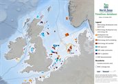
International map
An international overview map is included in the database. The map shows nine phases in the development of an offshore wind farm, from the search area phase to the decommissioning of an offshore wind farm.

NSEC
In 2016, the North Seas Energy Cooperation (NSEC) was established, a partnership of the energy ministers of the North Sea (and Irish Sea) countries to jointly promote the development of offshore renewable energy, reduce costs, and utilize space efficiently. Participating members are Belgium, Denmark, France, Germany, Ireland, Luxembourg, the Netherlands, Norway, and the European Commission. Due to Brexit, the United Kingdom has a separate status within this partnership, based on the NSEC-UK Memorandum of Understanding.
The TIMELINES database is accessible in the GNSBI Compendium viewer.
The map (pdf, 1.7 MB) can be found on the North Sea Portal