
North Sea Network Analysis 2025 maps shipping activity
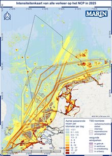
The North Sea Network Analysis for 2025 is now online. Commissioned by Rijkswaterstaat, research institute MARIN has mapped developments in North Sea shipping every year since 2021.
The network analyses have many users. Besides MOSWOZ and various parts of Rijkswaterstaat, these include the Netherlands Coastguard, seaports and maritime training institutes. MOSWOZ uses the results of the Network Analysis for several purposes, such as gaining insight into vessel movements in and around wind farms, and providing input for the SAMSOM model, which Rijkswaterstaat uses to calculate collision probabilities in the North Sea.
Vessel movements and trends
In 2025, a total of 247,279 vessel movements were observed in the Dutch part of the North Sea. Within the three main sub-areas bordering the coast, the number of vessel movements increased by approximately 1% (Figure i-1 in the report). The total number of vessel movements is roughly the same as in 2024.
The shift in the use of the traffic separation schemes (TSS), the international ‘motorways’ at sea, is continuing. Ships are increasingly choosing the West Friesland Deep Water Route. Deep-water routes are suitable for ships with a large draught.
Vessels not under command and ERTV deployments
In 2025, 120 ships reported to the Netherlands Coastguard that they were (temporarily) not under command. Most of these drifting vessels were foreign merchant ships. On one occasion, an ERTV (emergency response towing vessel) was deployed to establish a towline to a drifting ship: the oil tanker Eva Schulte. Twelve ships used their anchor to come to a stop.
In total, the ERTVs were deployed 35 times, with peaks in autumn and winter and a low in summer. A towline was established in 7% of incidents. This means that most incidents are resolved in other ways.
Occupancy of anchorage areas and shipping in offshore wind farms
Ships sometimes have to wait in anchorage areas before continuing their voyage. In 2025, the total number of ships using the anchorage areas decreased slightly. However, these anchorage areas were used more efficiently.
In the Borssele wind farm zone, the number of transits fell by 11% (−116), while Hollandse Kust Zuid showed an increase of 22% (+629). In Hollandse Kust Noord, traffic bound for the wind farm increased. In the Egmond aan Zee Offshore Wind Farm (OWEZ), traffic bound for the wind farm decreased. Section 8.4.3 of the report provides background information on these changes and figures.
Navigational behaviour and the weather
An important conclusion about navigational behaviour is that shipping makes use of the space available and, where space is limited, stays within safe limits. From wind force 6 and wave heights above 3 metres, ships near the Deep Water Route and Hollandse Kust Zuid did move outside the traffic lanes. Along the West Friesland Deep Water Route this is permitted, as no wind farms have yet been built along that route. At Hollandse Kust Zuid, this mainly involved bulk carriers that needed extra space.
Continuation of monitoring
The North Sea Network Analysis 2025 is the last of MARIN’s network analyses in a five-year series. Monitoring will continue, but in what form is not yet known. Would you like to stay informed? Remain a subscriber or subscribe to our newsflash now. You can find the North Sea Network Analysis 2025 (in Dutch) on Noordzeeloket under ‘Algemeen’ (General) in the report overview.