
Data collection in the North Sea
The North Sea is one of the most intensively used seas in the world, with great significance for the Dutch economy. In addition, it is also a valuable and vulnerable ecosystem. This intensive use puts great pressure on the North Sea. Future scenarios show that this pressure will only increase. To facilitate, stimulate and ensure all activities in the North Sea take place safely and monitor the boundaries of a healthy ecosystem, information is needed about the use and condition of the North Sea. Rijkswaterstaat plays a crucial role in gathering this information through sensors. These sensors collect, process and analyze various types of data that are essential for the monitoring and management of the marine environment, shipping safety, coastal protection, and other maritime activities.
The project Maritime Information Service Point (MISP)
Because of its expertise in the field of information provision, Rijkswaterstaat has been asked to set up, organize and manage a data service in the North Sea. In this project: Maritime Information Service Point (MISP), Rijkswaterstaat realizes, operates and manages the physical and digital infrastructure required to collect and distribute the data. Rijkswaterstaat does this in and around the wind farms that will be constructed in the North Sea in the (coming years) as part of the energy transition. The data that is collected can be divided into a number of categories:
1. Ecological data using bird radar and bat detection;
2. Monitoring of shipping using Automatic Identification System (AIS) and navigation radar;
3. Hydrological data such as wave height and water temperature;
4. Meteorological information such as wind, temperature, cloud height detection and visibility range;
5. Other data such as camera images, LoRa (telecom network), and data is collected for Air Traffic Control the Netherlands and the Land Registry.
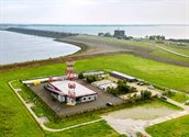
The Offshore Expertise Center
Rijkswaterstaat has built an Offshore Expertise Center (OEC) in Stellendam. The immediate reason for the expertise center was the need to test all of MISP's sensors in a realistic test setup. Testing at sea is an expensive and complex affair, hence the need for a test location on shore. After the test phase, the sensors are transported to the offshore wind farms and installed there.
In addition, the OEC is increasingly being used as a shared service for anyone interested in North Sea data.
Information provision (IP) at sea
In addition to the aforementioned projects, Rijkswaterstaat groups the IP projects and topics in the North Sea under the heading 'IP at Sea, the common thread that connects'. Below is a selection of these.
• Offshore Condition Based Maintenance;
• Digitization of Ecological Monitoring;
• RWS Fieldlab Connectiviteit Noordzee (RFCN).;
• North Sea Digitalization Implementation Program;
• 1 integrated nautical traffic image for the Coast Guard;
For more information, see the Digital North Sea website.