Ga naar de inhoud
beeldmerk-RijksoverheidRijkswaterstaatMinistery of Infrastructure and Water Management
Direct naar
  • About Noordzeeloket
  • FAQ
  • Dutch
  • Sitemap
Noordzeeloket
  • Home
  • News
  • Policy
  • Functions and use
  • Management
  • Network
  • Publications
  • Up-to-date Atlas
  • About Noordzeeloket
  • FAQ
  • Dutch
  • Sitemap
  1. Home ›
  2. Functions and use ›
  3. Offshore wind energy ›
  4. Free passage and shared use ›
  5. Nederwiek

Nederwiek wind farm zone

Specifics of the zone

Nederwiek wind farm zone lies between 100 and 120 km from the coastline, to the north-west of IJmuiden Ver wind farm zone, bordering on the UK section of the North Sea. So it is a long way from the mainland and, on completion, will not be visible from the coast.

NEDERWIEK WIND FARM ZONE

Location

Northwest of IJmuiden Ver

In use from

2030

In use untill

TBA

Number of eind turbines

TBA

Turbine output (MW)

TBA

Wind farm output (MW)

Approx. 6000

Surface area (km2)

Approx. 600

Operators

TBA

Sites

You will be able to find information about site decisions and issuance of sites on the website of RVO Bureau energieprojecten.

Do you want to compete for the permit for construction and operation of a wind farm in the Nederwiek Wind Farm Zone Site I-A in the North Sea? See the website Permit for wind farm Nederwiek I-A | RVO.nl

Through shipping

A corridor runs through the wind farm zone to allow shipping, such as the IJmuiden - Newcastle ferry, to travel towards the United Kingdom. In the southernmost site (I-A), a space is kept free for shipping.

Shared use

An Area Passport guide will be available on the opening of the Nederwiek wind farm zone. Zoning in this area passport will show where there is space in the wind farm for shared use.
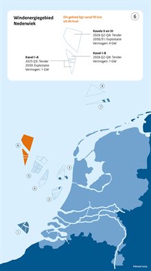

Nederwiek

WOZ_Kaarten_Windenergiegebieden_Website_Februari_2025_v16_NederwiekClick to enlarge (afbeelding: Nederwiek)

Wind energy areas and Windfarms

Wind energy areas and Windfarms
  • Offshore wind farm Egmond aan Zee (OWEZ)
  • Borssele wind farm zone
  • Hollandse Kust (zuid) Wind Farm Zone including Offshore Wind Farm Luchterduinen (LUD)
  • Hollandse Kust (noord) wind farm zone including Prinses Amalia Wind Farm (PAWF)
  • Hollandse Kust (west) wind farm zone
  • IJmuiden Ver Wind Farm Zone
  • Nederwiek
  • Ten noorden van de Waddeneilanden, including Gemini wind farms Buitengaats and ZeeEnergie
  • Doordewind

Windenergie op zee

Windenergie op zee
  • Energy transition in the North Sea
  • Preparatory work for wind farms
  • Offshore Grid
  • Inspection and enforcement
  • Free passage and shared use
  • Ecology
  • Start/Stop
  • International
  • Data collection in the North Sea
  • Shipping safety around offshore wind farms (MOSWOZ)
  • Laws and regulations, international treaties and policy
  • Sources
Share this
  • Delen op Facebook
  • Delen op LinkedIn
  • Delen op X

footer-afzender

About Noordzeeloket

This is Noordzeeloket. The fastest way to government information on the North Sea. On how the central government manages the North Sea, and how the space in the North Sea is divided. On what is possible and allowed in the North Sea and what rules and conditions apply. On where to go for which permit. On what national and international policy is in force.

Read more

Go directly to

  • Cookies
  • Privacy statement
  • Copyright
  • Archive

Contact

Please contact us with any questions or comments you may have.

Contact